


รับสำรวจที่ดินเพื่องานออกแบบภูมิสถาปัตยกรรม และงานสำรวจที่ดินรายแปลง |
฿ไม่ระบุ |
|
ชื่อผู้ประกาศ : คุณรักษ์ เบอร์โทรศัพท์ : 0871591587 โทรศัพท์มือถือ : 0871591587 ที่อยู่ : 95/253 ม.3 ต.คูคต อ.ลำลูกกา จ.ปทุมธานี 12130 การติดต่ออื่นๆ : 95/253 ม.3 ต.คูคต อ.ลำลูกกา จ.ปทุมธานี 12130 ร้าน RAK SURVEY |
รับงานสำรวจเบื้องต้นเพื่อการออกแบบและก่อสร้างโดยทีมงานที่มีประสบการณ์ทางด้านวิศวกรรมสำรวจ
รายละเอียดงานที่ทำ
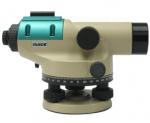
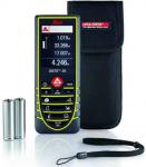
รับสำรวจรังวัดที่ดิน (Land Survey)
- สอบเขต , แบ่งแยกแปลงที่ดิน
- หาตำแหน่งที่ดิน
- ออกแบบและวางผังจัดสรรที่ดิน
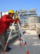
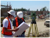
รับสำรวจเพื่อการก่อสร้าง (Construction Survey)
- เนื้อที่และปริมาตรดินตัด-ดินถม ( Cut-Fill )
- สำรวจทำผังบริเวณ , วางตำแหน่งลายเสาเข็ม , วางผังโครงการ , วางตำแหน่งสิ่งก่อสร้าง
รับสำรวจเก็บรายละเอียดภูมิประเทศ (Topographic survey)
- สำรวจเพื่อทำเส้นชั้นความสูง ( Contour line )
- ปริมาตรดินตัด-ดินถม ( Cut-Fill )
(บริการทั่วประเทศ)
Job Description
Construction Survey
เป็นบริการที่จัดทีมสำรวจ(Survey Teams) พร้อมเครื่องมือเเละอุปกรณ์สำรวจ ประจำไซด์งานก่อสร้างต่างๆเพื่อกำหนดตำเเหน่ง ผังอาคารหรือสิ่งก่อสร้าง พร้อมทั้งจัดทำหมุดควบคุม ภายในโครงการทั้งที่เป็นระบบ Grid Line หรือพิกัดฉาก (Co-ordinate System) รวมถึงระบบ UTM (Universal Transverse Mecator) ที่ใช้ระบบเดิมหรือ WGS-84
Topographic Survey
รับงานสำรวจเพื่อทำเเผนที่ภูมิประเทศ เเสดงรายละเอียดของพื้นที่ ขอบเขตของพื้นที่ รวมทั้งเส้นชั้นความสูง(Contour Line) เพื่อใช้ประโยชน์สำหรับการออกเเบเพื่อการก่อสร้างโครงการต่างๆ
Route Survey
รับงานสำรวจเส้นทางเพื่อใช้ประกอบการออกเเบบ ถนน คลอง หรืออื่นๆ โดยเเผนที่จะเเสดงภายในบริเวณเส้นทางที่กำหนด รวมทั้งจัดทำหมุดวงรอบเเละหมุดระดับ เพื่อใช้ประโยชน์ในการก่อสร้างต่อไป
งานสำรวจประเภทอื่นๆ
รับวางตำแหน่งเสาเข็ม ฐานรากอาคาร
รับสำรวจเพื่อวางตำแหน่ง R.O.W
รับสำรวจเพื่อคำนวนงานดิน(Earth Works
-รับออกแบบ เขียนแบบ
บริการงานสำรวจและออกแบบ :
1. Survey for Development plans :
รับสำรวจที่ดินเพื่องานออกแบบภูมิสถาปัตยกรรม และงานสำรวจที่ดินรายแปลง
2. Construction Surveys :
รับงานสำรวจเพื่องานก่อสร้าง
3. Hydrographic Surveys :
รับงานสำรวจทางอุทกศาสตร์ เช่น งานสำรวจทางทะเล และแหล่งน้ำ
4. Survey for Infrastructures :
รับงานสำรวจสาธารณูปโภค เช่น งานถนน งานประปา งานท่อก๊าซ และระบบบำบัดน้ำเสีย
Construction Surveying
Construction is one of the largest industries in the world. Surveying plays an extremely important role in any construction project. Construction surveying can take many forms. It is used to establish the location and alignment of highways, bridges, buildings, pipes, and other man-made objects. After large-scale projects are completed, an "as-built" survey is performed to locate any modifications that were made to the plans during construction.
Highway surveys involve the location of alignments and computation of volumes materials that must be added, removed, or moved. It initially requires a topographic survey of the site. For large projects, photogrammetric methods will be used to develop the base map. The base map is used by surveyors and other professional to create a base plan for the project. After the alignment has been established, the quantities of earth that must be added or removed are computed. The goal of most projects is to minimize the hauling distances of the earth. This is done using mass diagrams. Eventually surveyors layout the elevation and slope of the various subgrades, base, and top coat materials. The end result is a smooth alignment with smooth transitions from straight to curved sections allowing for safe public transportation.
รับงานสำรวจรับงานเซอร์เวย์รับวางหมุดคอนทัวสำรวจวางลายก่อสร้างเซอร์เวย์รับงานสำรวจถนน